Our Offer

Remote sensing

Semantic 3D Mesh models

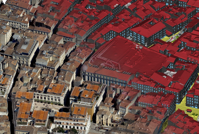
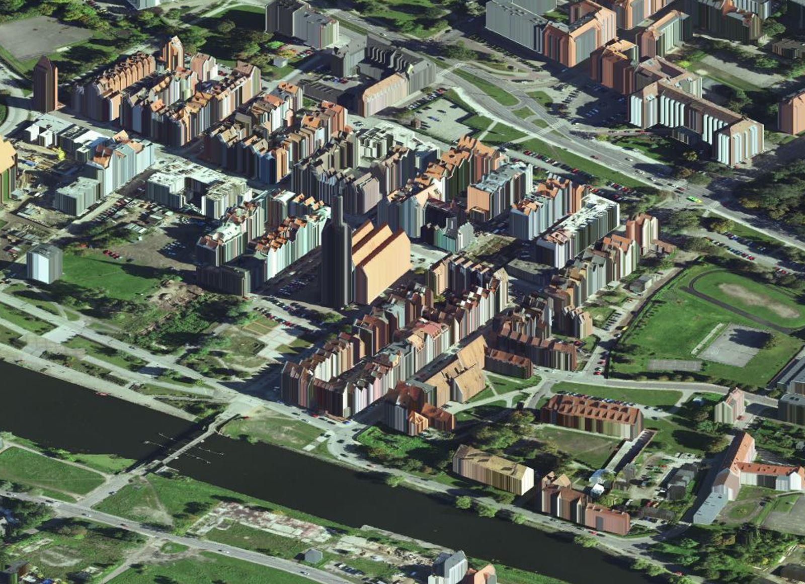
Using data from our hybrid airborne sensor, we integrate 3D Mesh models of the highest quality with semantic information. Such combination of 3D mesh models fragments with information about objects representing them is based on the results of semantic segmentation of oblique images and point clouds.

The technology was developed in collaboration with scientists from the Warsaw University of Technology.


Semantic 3D Mesh models

Object detection and segmentation of aerial imagery

We offer automatic detection of objects on oblique images, as well as their visualisation and extraction of geographical coordinates. Moreover, we perform segmentation of full content of images, where we classify image content according to individual customer needs. In this process, we extract, among others: building facades, windows, roofs, impermeable and permeable surfaces, including greenery.


Object detection and segmentation of aerial imagery

Geospatial Intelligence analysis

Due to the unique vertical integration of sensors, a dedicated flying unit, data acquisition methodologies and artificial intelligence algorithms used throughout the service delivery process, we offer advanced geospatial intelligence analyses for:

- crop insurance industry,

- environmental protection - for monitoring of Natura 2000 non-forest natural habitats and monitoring of invasive and expansive plant species;

- emergency management - to provide up-to-date geospatial data and analysis during or shortly after an event;

- the energy and telecommunications industry.


Geospatial Intelligence analysis

Vegetation analysis

By using multispectral remote sensing data captured from our sensors, we take inventory of flora and assess vegetation in respect of species groups and plant height, simultaneously eliminating the necessity to undertake expensive field inventorying. The algorithms associated with artificial intelligence, neural networks, machine learning and deep learning are utilised for the purposes of carrying out the aforementioned analyses.


Vegetation analysis

Orthophoto maps

We prepare orthophoto maps and orthoplans based on PAN, RGB, CIR, NIR and RGBN aerial imagery for small-size areas, such as towns, state forest districts, through medium-size areas, such as national parks or  poviats (districts), up to much bigger areas, such as voivodeships or entire countries.


Orthophoto maps

True Ortho

True Ortho is vertical imaging without the presence of a tilt. Developing high-quality True Ortho requires proper flight mission planning (increasing coverage between images) and optimal camera selection (such as our Leica CityMapper-2 sensor with a narrow angle of view). This gives the analyst a direct view of the terrain surrounding the building, and this, among other things, greatly facilitates spatial planning and spatial analysis.


True Ortho

LiDAR (Light Detection and Ranging)

We specialise in the classification of aerial scanning point clouds characterised by standard density and high density (exceeding 30 points/m2). Moreover, we also develop and process shallow bathymetry data acquired by means of the green laser.


LiDAR (Light Detection and Ranging)

Terrain models

Basing on a cloud of LiDAR points or stereodigitisation, we develop comprehensive numerical terrain models, digital surface models and standardised numerical vegetation models.


Terrain models

Stereodigitisation

We develop three-dimensional vector data, taken from aerial images, on a stereoscopic model with the accuracy of up to 10 centimetres. We have relevant experience in interpretation and acquisition of 3D data concerning open engineering structures, topographic relief (terrain), surface water, vegetation complexes, individual trees, individual rocks (boulders), aerials (antennas) and moving objects (e.g. animals).


Stereodigitisation

Vectorisation

We develop two-dimensional analyses by means of vectorisation of orthophoto maps and analogue map rasters, as well as three-dimensional analyses based on a classified cloud of LiDAR points. The end-product of this process is an editable delaminated vector file featuring division into surface structures, linear structures, point structures, text descriptions and editorial components. We are ready to execute photo-interpretation works characterised by a high level of detail, both in respect of 2D data and 3D data, referring to natural sites (structures), technical facilities and land development (site development).


Vectorisation

3D building models

Our offer includes 3D building models performed in CityGML standard at three levels of detail: LoD1, LoD2, LoD 3.


3D building models

OPEGIEKA Sp. z o.o.

Click here for directions.

Head Office

Aleja Tysiąclecia 11

82-300 Elbląg

phone: +48 (55) 237 60 00

fax: +48 (55) 237 60 01

E-mail address:

sky@opegieka.pl

Branch in Warsaw

ul. Grzybowska 80/82 lok. 700

00-844 Warszawa